2026–27 El Niño: What Monterey Peninsula Homeowners Should Know Before Winter
Last updated: September 28, 2026
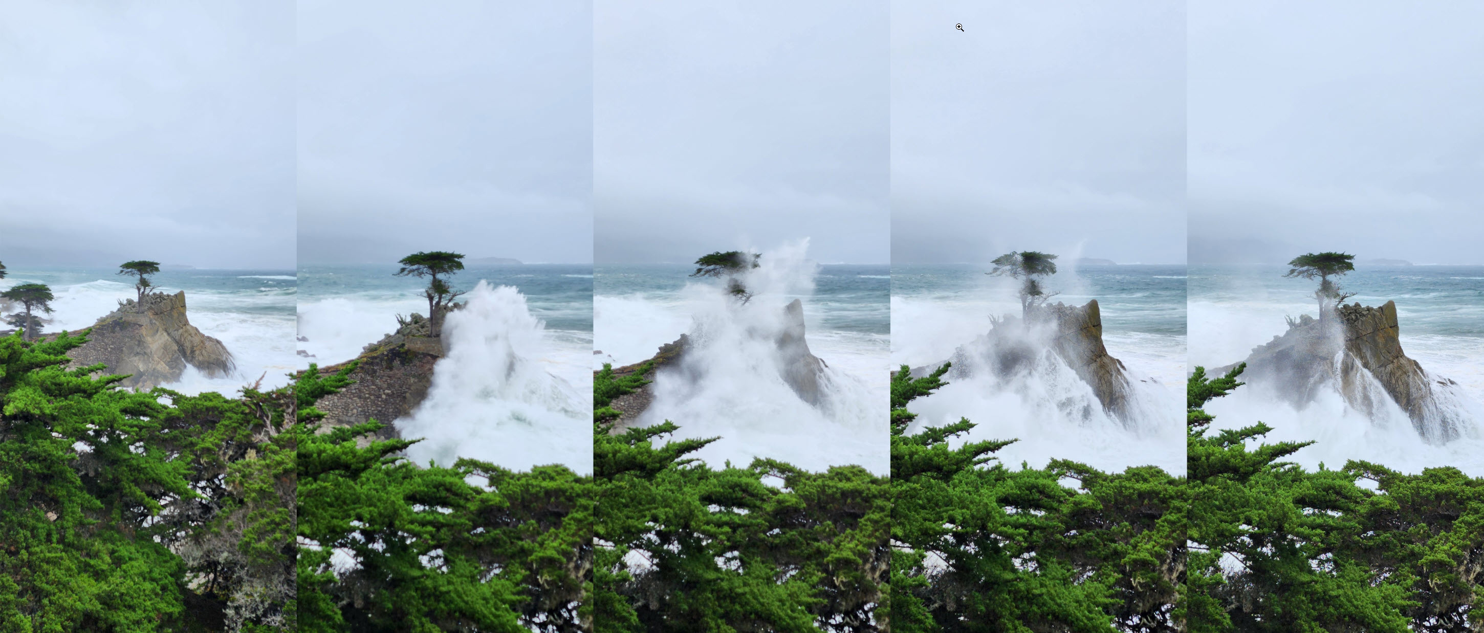
I think the developing 2026–27 El Niño is worth paying attention to if you own a home on the Monterey Peninsula.
That does not mean we are guaranteed a repeat of one of California's historically destructive El Niño winters. El Niño changes probabilities; it does not tell us exactly where individual storms will go, how much rain Monterey County will receive, or whether a particular property will experience problems.
What we do know is that NOAA says the current El Niño is strengthening and has a greater than 90% chance of becoming a very strong event during the fall and winter of 2026–27. That makes this a good time to look at what past winters have taught us and, more importantly, what homeowners can reasonably inspect and prepare before the major winter storms arrive.
The interesting thing about the Monterey Peninsula is that El Niño does not present exactly the same concerns everywhere. A home in Pebble Beach may have significant tree and drainage considerations. A home near the Pacific Grove coastline may be more exposed to high surf and coastal flooding. Parts of Carmel Valley have a long relationship with the Carmel River. And homes in the Carmel Highlands add steep terrain, coastal bluffs and Highway 1 access to the equation.
The short version:
A strong El Niño does not automatically mean a disastrous winter on the Monterey Peninsula. But given NOAA's current forecast, this is a particularly good year to pay attention to roofs, gutters, drainage, trees, slopes, low-lying areas and coastal exposure before the ground becomes saturated and storms begin arriving one after another.
How Strong Could the 2026–27 El Niño Become?
NOAA's September 10, 2026 ENSO Diagnostic Discussion says El Niño is continuing to strengthen and gives it a greater than 90% chance of becoming a very strong event during the Northern Hemisphere fall and winter of 2026–27.
There are two numbers in NOAA's current forecast that are worth separating.
NOAA's official ENSO Strength Probabilities show a 98% probability that the October–November–December period reaches the "very strong" category, defined by NOAA as a three-month Relative Oceanic Niño Index, or RONI, of at least +2.0°C.
Separately, NOAA's September discussion gives a 75% probability that the October–December RONI reaches at least +2.5°C. NOAA describes that threshold as a potentially historic event that would exceed the strength of previous El Niño events in the record dating to 1950.
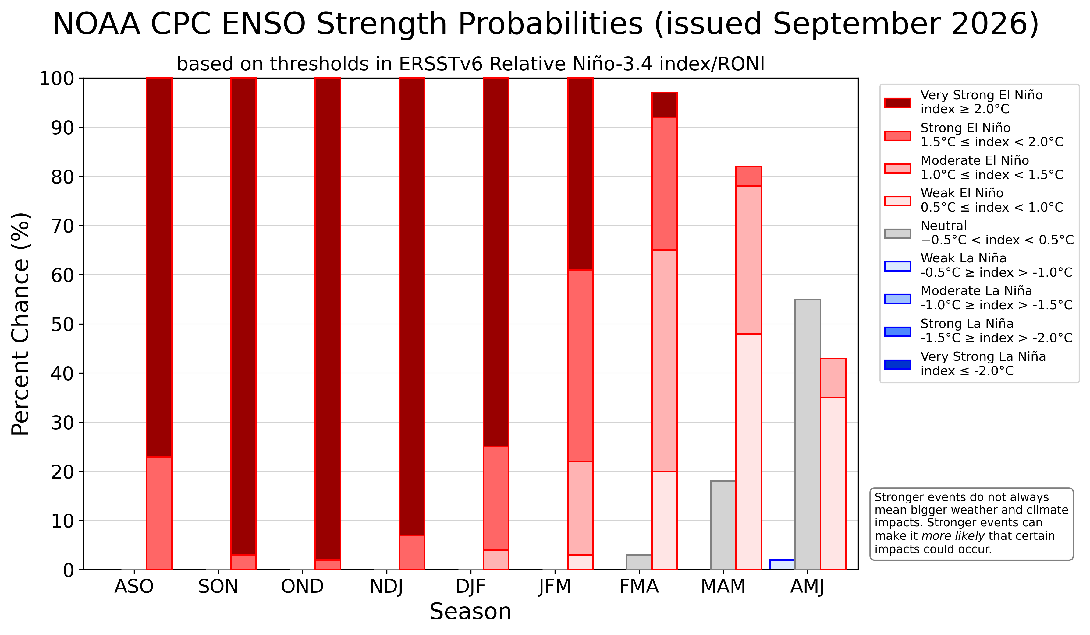
NOAA's September 2026 ENSO strength forecast shows an exceptionally high probability of a very strong El Niño during fall and winter 2026–27. Source: NOAA Climate Prediction Center. Click the graphic for the current NOAA forecast.
Those numbers sound dramatic, but NOAA also makes an important point: the strength of an El Niño does not necessarily determine the strength of its impacts in a particular location.
That distinction matters for us.
El Niño Is Not a Storm
One of the easiest ways to misunderstand El Niño is to think of it as a giant storm headed toward California.
It isn't.
El Niño is a large-scale ocean and atmospheric pattern in the tropical Pacific. It can alter the jet stream, storm tracks, ocean temperatures and the odds of certain weather patterns occurring over the course of a season.
What Monterey Peninsula homeowners actually experience are the individual weather events that develop within that broader pattern: heavy rain, atmospheric rivers, high winds, large waves, saturated soils, flooding, erosion and occasionally landslides.
And the sequence of those storms may be just as important as the seasonal rainfall total.
A significant storm arriving after several dry weeks is one thing. Multiple storms arriving close together after the ground is already saturated can create an entirely different set of problems.
Atmospheric Rivers May Matter More Than the El Niño Label
We got a very good local reminder of this during the February 3–5, 2024 atmospheric river and windstorm.
The National Weather Service reported damaging winds and heavy rain throughout the Bay Area and Central Coast. Saturated soils combined with high winds to bring down numerous trees and cause widespread power outages.
At Pebble Beach, the National Weather Service recorded a 68-mph wind gust on February 4, 2024.
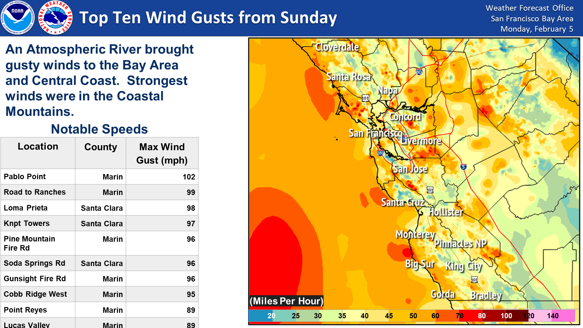
Peak wind gusts during the February 2024 atmospheric river and windstorm. The National Weather Service recorded a 68-mph gust at Pebble Beach. Source: National Weather Service San Francisco Bay Area.
That storm did not require an El Niño label to demonstrate the combination that concerns me most as a homeowner: wet soil followed by strong wind.
The lesson for the coming winter is not that every atmospheric river will be severe. It is that repeated storms can change the condition of the ground, trees, drainage systems and slopes as winter progresses.
What Happened During the 1997–98 El Niño?
The 1997–98 El Niño provides useful Monterey County history because it shows what can happen when repeated storms arrive on already saturated ground.
According to Monterey County's historical flood records, a series of El Niño storms struck the county in February 1998. The close timing of the rainfall was particularly important because heavy rain repeatedly fell on ground that had not had time to dry.
The County reports that approximately 50 roads and highways were closed or restricted, primarily because of washouts, landslides and mudslides. Several communities were evacuated, and by the end of the first week of February at least 6,600 homes and businesses had experienced power outages for varying periods.
Monterey County was declared a disaster area. County records estimate losses from the February 1998 events at more than $38 million at the time, including more than $7 million in agricultural losses.
That history does not tell us that 2026–27 will repeat 1997–98. It tells us why storm sequencing, soil saturation, drainage and terrain deserve attention when a strong El Niño is developing.
1982–83: Another Important Monterey Bay El Niño
The 1982–83 El Niño is particularly relevant to the Monterey Peninsula because the U.S. Geological Survey documented what happened along Monterey Bay.
USGS researchers found that the 1982–83 El Niño produced unusually frequent and intense storms along California's Central Coast. The storms caused much greater than normal beach erosion in Monterey Bay, damaging coastal structures, eroding coastal cliffs and removing sand from coastal dunes.
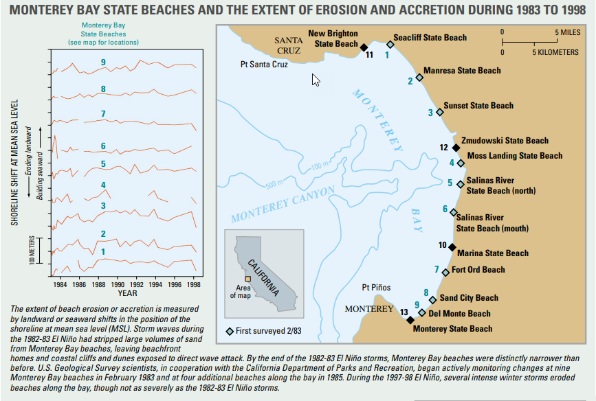
USGS monitoring shows how Monterey Bay beaches changed between the major 1982–83 and 1997–98 El Niño events. Monitored locations included Del Monte Beach, Sand City, Fort Ord, Marina and beaches farther north around Monterey Bay. Source: U.S. Geological Survey.
USGS continued monitoring Monterey Bay beaches between the major 1982–83 and 1997–98 El Niños. That work is particularly useful because it demonstrates something homeowners should keep in mind: even within Monterey Bay, individual beaches and sections of coastline do not necessarily react to storms in exactly the same way.
But a Strong El Niño Does Not Guarantee a Wet Monterey Peninsula Winter
This may be the most important point in the entire article.
A very strong El Niño increases the likelihood of certain large-scale weather patterns, but it does not guarantee that Monterey County will experience extraordinary rainfall or that every part of California will see the same impacts.
NOAA itself cautions that El Niño strength does not automatically translate into impact strength.
The strong 2015–16 El Niño is a good example of why regional differences matter. USGS found substantially different beach responses in Northern, Central and Southern California, driven in part by differences in waves and storm patterns.
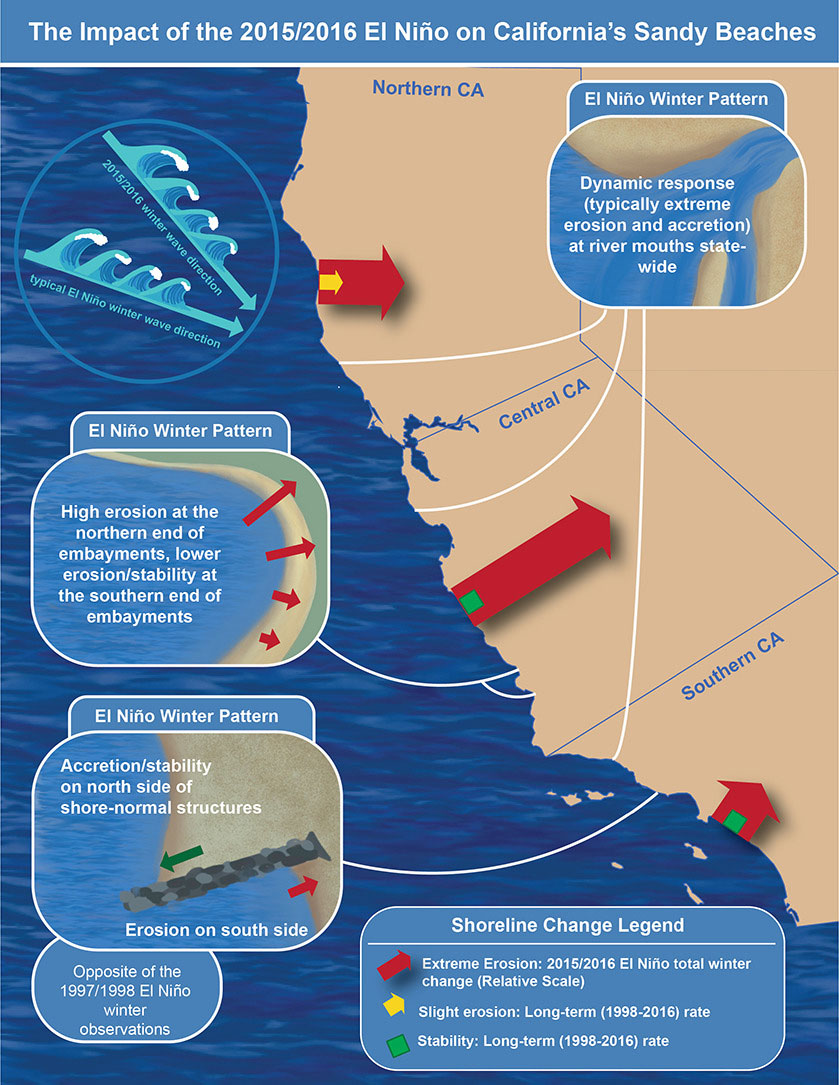
California beaches did not all respond the same way during the strong 2015–16 El Niño. This USGS graphic illustrates regional differences, including the Central Coast. Source: U.S. Geological Survey. Public domain.
So I would not prepare for winter based on a prediction that "El Niño means it is going to flood."
I would prepare based on the more practical question:
If we do receive several significant storms close together, where is this particular property most vulnerable?
One El Niño — Different Risks Around the Monterey Peninsula
That question produces different answers depending on where you live.
Pebble Beach: Trees, Wind, Drainage & Coastal Exposure
Pebble Beach combines forest, coastal exposure, sloping terrain and a large number of mature trees.
For many properties, one of the biggest winter concerns is the combination of saturated soil and wind. The February 2024 storm was a useful real-world example: the National Weather Service specifically noted that saturated soils and strong winds contributed to widespread fallen trees.
That does not mean a healthy-looking Monterey pine or cypress is going to fall in a storm. It means this is a reasonable time to look more carefully at trees near homes, driveways, roads and utility lines.
Homeowners may want to look for dead or broken limbs, noticeable lean, recently exposed roots, soil erosion around the root zone, cavities, major trunk damage, declining crowns or significant changes from the previous year. A qualified arborist can evaluate conditions that are difficult to assess visually.
Drainage matters as well. Pebble Beach's forested terrain means water may move very differently from one property to another. Roof drainage, driveway runoff, swales, retaining areas and water coming from neighboring or uphill property can all become much more obvious during sustained rain.
Pacific Grove: High Surf, Coastal Flooding & Ocean View Boulevard
Pacific Grove has a completely different type of exposure along parts of its shoreline.
Anyone who has spent winters around Ocean View Boulevard, Point Pinos or Asilomar knows that high surf can be impressive even in an ordinary winter. During El Niño, another factor enters the equation: coastal water levels can be elevated above their normal background level.
That does not mean warmer El Niño water simply creates bigger waves. The process is more complicated.
NOAA explains that El Niño can raise West Coast sea levels through warmer, expanded ocean water and changing ocean and atmospheric conditions. Normal tides then ride on top of that higher background water level. Add a particularly high tide, storm surge, large swell and wave run-up, and water can reach farther inland than any one factor would produce by itself.
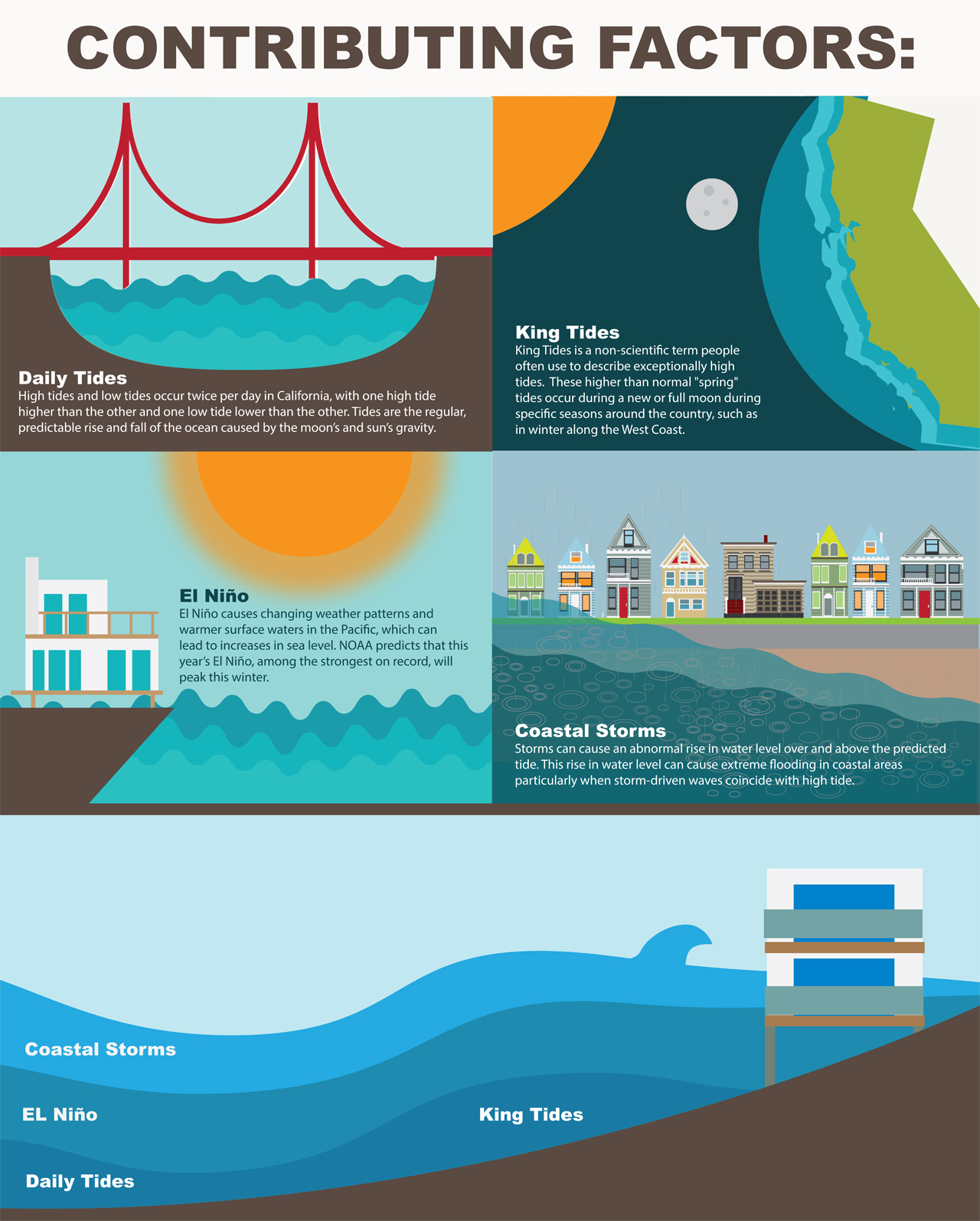
Why El Niño can increase coastal flooding risk: daily tides, exceptionally high tides, elevated El Niño sea levels and coastal storms can combine to produce higher total water levels. Source: NOAA National Ocean Service.
This is why I would pay particular attention to forecasts that combine large swell + high tide + strong onshore storm conditions. For Pacific Grove's exposed coastline, that combination can matter more than simply looking at the amount of rain in the forecast.
Carmel-by-the-Sea & Greater Carmel: Older Homes, Drainage, Trees & the Coast
Carmel presents yet another mix of issues.
Many Carmel-by-the-Sea homes are older, and some were built long before today's roofing, drainage, foundation and waterproofing standards. That does not make them inherently problematic—it simply makes routine inspection particularly worthwhile before a potentially wet winter.
I would pay attention to roof condition, flashing, gutters and downspouts, crawlspaces, drainage around foundations, exterior stairs and retaining walls, and places where water has historically collected.
Carmel's small lots can also create drainage relationships between neighboring properties. Water coming off one roof, patio or uphill lot may not stay neatly within a property line once rainfall becomes intense.
Outside the incorporated village, greater Carmel adds larger wooded lots, hillside neighborhoods and coastal areas such as Carmel Point. The risk profile can change substantially within only a few miles.
Carmel Valley: The Carmel River, Creeks, Low-Lying Areas & Hillsides
In Carmel Valley, I would think about water somewhat differently.
The Carmel River has a long history of flooding in low-lying portions of the Valley. Monterey County's historical records document flooding in areas including Robles del Rio, Mission Fields, areas near Schulte Road and Rio Road, along with other locations near the river.
That does not mean all of Carmel Valley is a flood risk. Far from it. Carmel Valley encompasses everything from river-bottom land to elevated hillsides and mountain properties.
It does mean buyers and owners should understand a property's elevation and relationship to the river, tributary creeks, drainage channels and surrounding terrain.
Farther up the Valley, private roads, culverts, creek crossings, long driveways and hillside drainage can be just as important as the house itself. Heavy rain may affect access even when the residence is well above a floodplain.
Carmel Highlands: Slopes, Drainage, Coastal Bluffs & Highway 1
Carmel Highlands combines some of the Peninsula's most dramatic scenery with steep coastal terrain.
Here I would be thinking about hillside drainage, retaining systems, erosion, bluff conditions, vegetation, trees and access.
USGS research along the Big Sur coast found that heavy precipitation during the 1982–83 and 1997–98 El Niños raised groundwater levels and contributed to destabilized slopes. Large landslides repeatedly affected Highway 1 along the steep coast south of Carmel.
A Carmel Highlands homeowner should not assume that history means a particular lot is unstable. Geology is extremely site-specific. But if a property already has drainage, retaining-wall, slope or bluff concerns, a potentially active winter is a good reason to address them with the appropriate professionals before prolonged rain begins.
Access is another consideration. A house itself can come through a storm without damage while a fallen tree, slide or Highway 1 closure still disrupts travel.
Monterey: Beaches, Hillsides, Trees & Neighborhood Drainage
Monterey is difficult to summarize with a single winter risk because its neighborhoods are so geographically different.
Del Monte Beach and lower coastal areas have different concerns than elevated neighborhoods such as Skyline Forest, Alta Mesa or portions of Monte Vista and Mar Vista.
Near the shoreline, high surf, beach erosion and drainage can matter. In elevated or forested neighborhoods, homeowners may be more focused on trees, slopes and how water moves across a lot.
Older Monterey homes may also have drainage or foundation systems that deserve additional attention before a prolonged wet period.
The larger point is that "Monterey weather" is not enough information. The specific neighborhood, elevation, terrain and property characteristics matter.
What About Trees?
Trees deserve their own discussion, particularly in Pebble Beach, Pacific Grove, Carmel, Monterey and other forested portions of the Peninsula.
I would not assume that every mature tree represents a storm hazard. Mature Monterey pines, cypress and oaks are part of what makes many of these neighborhoods special.
But wind behaves differently when soil becomes saturated. Root anchorage can become less effective, and pre-existing problems may become more consequential.
Before winter, homeowners can visually check for newly dead branches, damaged trunks, unusual lean, exposed or disturbed roots, soil erosion, cavities, fungal growth or a noticeable decline in the canopy.
If a large tree could reach a house, driveway or neighboring property and something looks questionable, that is a good reason to have a qualified arborist inspect it rather than trying to diagnose the tree yourself.
Where Does the Water Go?
This is probably the simplest question I would ask at almost any Monterey Peninsula property before winter:
When a lot of rain falls in a short period of time, where does the water go?
Walk around the property and follow the likely path.
- Are the gutters clear and properly attached?
- Where do the downspouts discharge?
- Does water move away from the foundation or toward it?
- Are area drains and catch basins clear?
- Are driveway drains functioning?
- Is there evidence of previous pooling or standing water?
- Are retaining-wall drains functioning?
- Can water arrive from an uphill neighboring property?
- Are crawlspace vents, doors or low openings vulnerable?
- Has erosion changed the way water moves across the property?
A drain that works perfectly during ordinary rain can behave very differently when leaves, pine needles and debris arrive at the same time as several inches of rain.
A Practical Pre-Winter Checklist for Monterey Peninsula Homeowners
I am not suggesting that homeowners overreact to the El Niño forecast. I am suggesting using the forecast as a reason to take care of ordinary maintenance while conditions are still relatively easy to work in.
Before the heart of winter, I would consider:
- Cleaning gutters, roof valleys, downspouts and exterior drains.
- Confirming downspouts move water away from the foundation.
- Looking for roof leaks, damaged flashing and obvious roof wear.
- Checking crawlspaces, basements and low areas for evidence of previous moisture.
- Inspecting exterior drains, swales and driveway drainage.
- Looking at retaining walls and slopes for noticeable changes or cracking.
- Having questionable large trees evaluated by a qualified arborist.
- Removing dead limbs and unsecured outdoor objects before wind events.
- Understanding whether the property lies in or near a mapped flood area.
- Reviewing insurance coverage and understanding deductibles and exclusions before a storm occurs.
- Keeping flashlights, batteries and basic supplies available for power outages.
- Knowing how to receive Monterey County and National Weather Service emergency alerts.
For properties near the coastline, river, creek, bluff or steep slope, the appropriate preparation may be more property-specific and could involve an engineer, drainage contractor, arborist, geologist, insurance professional or local agency.
Also remember that work involving coastal bluffs, shoreline protection, significant grading or other development may require permits. The California Coastal Commission's 2026–27 El Niño guidance specifically recommends checking before undertaking work that may require coastal authorization.
What Buyers Can Learn From Looking at a Home in the Rain
There is actually a real estate advantage to shopping for a home during winter weather.
A sunny-day showing tells you what the house looks like when everything is dry.
A rainy-day showing can tell you considerably more.
You may be able to see how the gutters perform, where driveway water runs, whether the yard drains, whether water collects next to the foundation, how a steep driveway behaves, whether the crawlspace smells damp and how exposed the property feels during wind and rain.
For a Monterey Peninsula buyer, those observations can be valuable because two homes only a few blocks apart can have very different drainage, wind, tree and coastal characteristics.
This is one of the reasons I encourage buyers to evaluate the property and micro-location, not simply the city name or ZIP code.
What Sellers Should Consider
If you are thinking about selling a Monterey Peninsula home over the next six to twelve months, winter preparation can have another benefit.
Deferred drainage, roof, tree or moisture problems have a way of becoming visible during inspections—especially after a wet winter.
Addressing routine maintenance early can give you more control than discovering the issue after a buyer's inspector finds it.
That does not mean undertaking every possible repair before selling. The right decision depends on the property, the cost, the likely buyer and your timeline.
But understanding the condition of the roof, drainage, trees, slopes, crawlspace and exterior before coming to market gives you better information for making that decision.
So, How Concerned Should Monterey Peninsula Homeowners Be?
I would describe the current NOAA forecast as something to take seriously without assuming the worst.
As of September 28, NOAA is forecasting a very strong 2026–27 El Niño, and there is a meaningful possibility that it reaches an exceptionally high strength later this fall.
We also have plenty of local history showing that the Monterey Peninsula and Monterey County can experience significant effects when powerful storms arrive repeatedly: flooding, downed trees, erosion, landslides, power outages and coastal impacts.
At the same time, no seasonal El Niño forecast can tell us exactly how many storms will reach the Monterey Peninsula or how much rain a particular neighborhood will receive.
So rather than trying to predict the weather months in advance, I think the useful approach is much more practical:
Understand the vulnerabilities of your particular property, take care of routine maintenance now, and pay attention to individual storm forecasts as winter develops.
That advice makes sense in any Monterey Peninsula winter. The current El Niño forecast simply gives us a particularly good reason not to put it off.
Frequently Asked Questions About the 2026–27 El Niño
Is a strong El Niño expected for winter 2026–27?
Yes. As of September 2026, NOAA says El Niño is strengthening and gives a greater than 90% chance of a very strong event during the Northern Hemisphere fall and winter of 2026–27. NOAA's September strength forecast assigns a 98% probability to the very-strong category for October through December.
Does that mean the Monterey Peninsula will definitely have a very wet winter?
No. A strong El Niño changes the probability of certain weather patterns but does not guarantee above-average rainfall in Monterey County. NOAA specifically cautions that the strength of an El Niño does not necessarily correspond with the strength of its impacts in a particular location.
What happened in Monterey County during the 1997–98 El Niño?
Monterey County records show that repeated February 1998 storms caused extensive flooding, landslides and mudslides. Approximately 50 roads and highways were closed or restricted, several communities were evacuated, at least 6,600 homes and businesses experienced power outages for varying periods, and losses from the February events were estimated at more than $38 million at the time.
Why could Pacific Grove face increased coastal flooding risk during El Niño?
El Niño can elevate background sea levels along the California coast. High tides then occur on top of that elevated water level. When high tides coincide with storm surge, large waves and wave run-up, low-lying and exposed coastal areas can experience higher total water levels and greater coastal flooding or erosion.
Is Carmel Valley at risk from El Niño?
Risk varies considerably throughout Carmel Valley. Properties near the Carmel River, creeks and low-lying areas may have different flood considerations from hillside and mountain properties. Rural roads, culverts, drainage, creek crossings and slopes can also become important during prolonged heavy rain.
Why are trees a concern in Pebble Beach?
Pebble Beach contains extensive mature forest. When soils become saturated, strong winds can make already weakened or compromised trees more vulnerable. The February 2024 atmospheric river provided a local example, when saturated soils and high winds caused numerous downed trees and widespread power outages and the National Weather Service recorded a 68-mph gust at Pebble Beach.
Are atmospheric rivers caused by El Niño?
No. El Niño and atmospheric rivers are separate phenomena. El Niño can influence larger-scale atmospheric patterns and storm tracks, while atmospheric rivers are concentrated corridors of water vapor that can produce heavy rainfall when they reach the California coast.
What should Monterey Peninsula homeowners do before winter?
Start with routine preparation: inspect the roof, clean gutters and drains, understand where stormwater flows, look for signs of drainage or moisture problems, evaluate questionable trees, inspect slopes and retaining areas, review insurance coverage and stay informed about individual storm forecasts and emergency advisories.
We Will Keep Updating This Guide
NOAA updates its ENSO outlook regularly, and the forecast will become more useful as we get closer to winter.
I will continue updating this page when there are meaningful changes in the NOAA forecast or when new information becomes available that is particularly relevant to homeowners on the Monterey Peninsula.
If you own a home here—or you are considering buying one—the most useful question is usually not simply whether a property is in Pebble Beach, Carmel, Pacific Grove, Monterey, Carmel Valley or Carmel Highlands.
It is understanding how the specific property relates to trees, water, terrain, coastline, drainage and its immediate surroundings.
That kind of property-specific understanding is an important part of how we approach real estate on the Monterey Peninsula.
Mark Bruno
Monterey Peninsula Home Team
Keller Williams Coastal Estates
(831) 917-8190
This article is intended as general homeowner and real estate information. Conditions vary significantly by property. Questions involving structural conditions, trees, geology, drainage, flood risk, insurance or coastal permitting should be evaluated by appropriately qualified professionals or agencies.
Sources & Further Reading
- NOAA Climate Prediction Center — ENSO Diagnostic Discussion
- NOAA Climate Prediction Center — Official ENSO Strength Probabilities
- NOAA National Ocean Service — Coastal Flooding in California
- California Coastal Commission — 2026–27 El Niño Property Preparation
- National Weather Service — February 3–5, 2024 Atmospheric River
- Monterey County Water Resources Agency — Historical Flooding
- U.S. Geological Survey — Changes to Monterey Bay Beaches From 1982–83 Through 1997–98
- U.S. Geological Survey — El Niño 2015–16 and California Sandy Beaches
- U.S. Geological Survey — Big Sur Coastal Landslides and Active Slopes